A sustainable life: Interview with Partner in Conservation Harold Hart

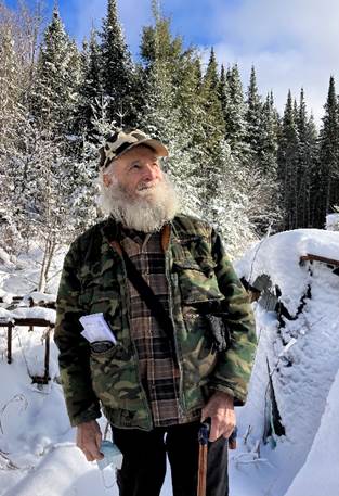
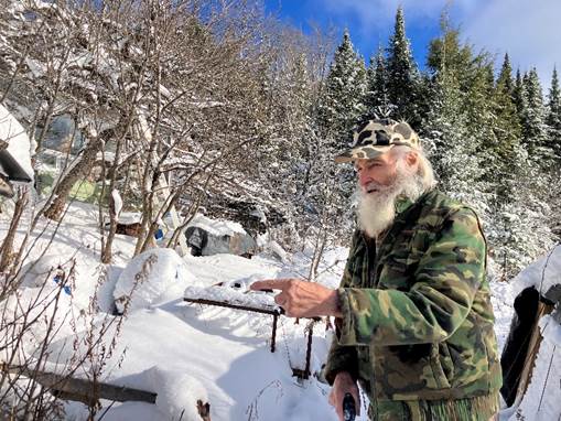
The morning sun lights up fresh snow adorning conifers and old apple trees next to Harold Hart’s home on a country road near the village of Harcourt, Ontario. Harold points to fisher tracks outside his front door, and to poplar stumps indicating local beavers have been busy putting up food for winter.

By modern standards, Harold lives an unconventional life — one that prioritizes basic human needs. He draws cool water from a well, heats his home with a wood stove, and uses a solar system to power his lights, small fridge and DVD machine. In his cold-storage room, he has several bushels of apples from his orchard. Dried apple slices and preserved berries give him fruit throughout the winter. When he stopped driving a few years ago, he would walk to town for his mail, food staples and supplies, or get a lift from a friend nearby. Perhaps his only nod to modern technology is the cellphone he uses to text and speak with friends and family.

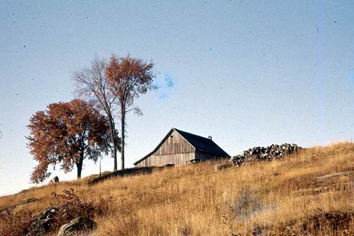
But Harold comes by his sustainable life honestly. When he was 10 years old in 1949, his parents moved their young family from the manufacturing centre of Oshawa Ontario to a peaceful 100-acre farm with an apple orchard near Harcourt. They put $300 down and paid the balance of $1,700 on installments of $10 per month.

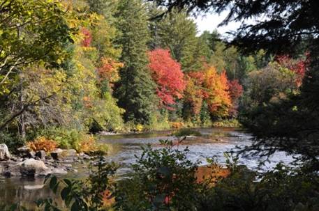
Now in his 80s, Harold has spent most of his life in the natural world. He made his living as a trapper. Over time, he acquired acreages in the bush to expand his lines and ensure a sustainable wildlife population. One parcel of lands he acquired resides in the Highlands Corridor and consists of about 375 acres, including forests, creeks and wetlands, due south of Harcourt, near Highway 118.

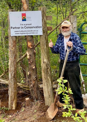
Because he cares about his lands and wildlife, and wants to protect them from future development, Harold signed up last year as a Partner in Conservation with the Haliburton Highlands Land Trust. For his 375-acre parcel, he was able to take advantage of a complimentary forest management plan, and related tax incentive, through a grant received by the Land Trust.

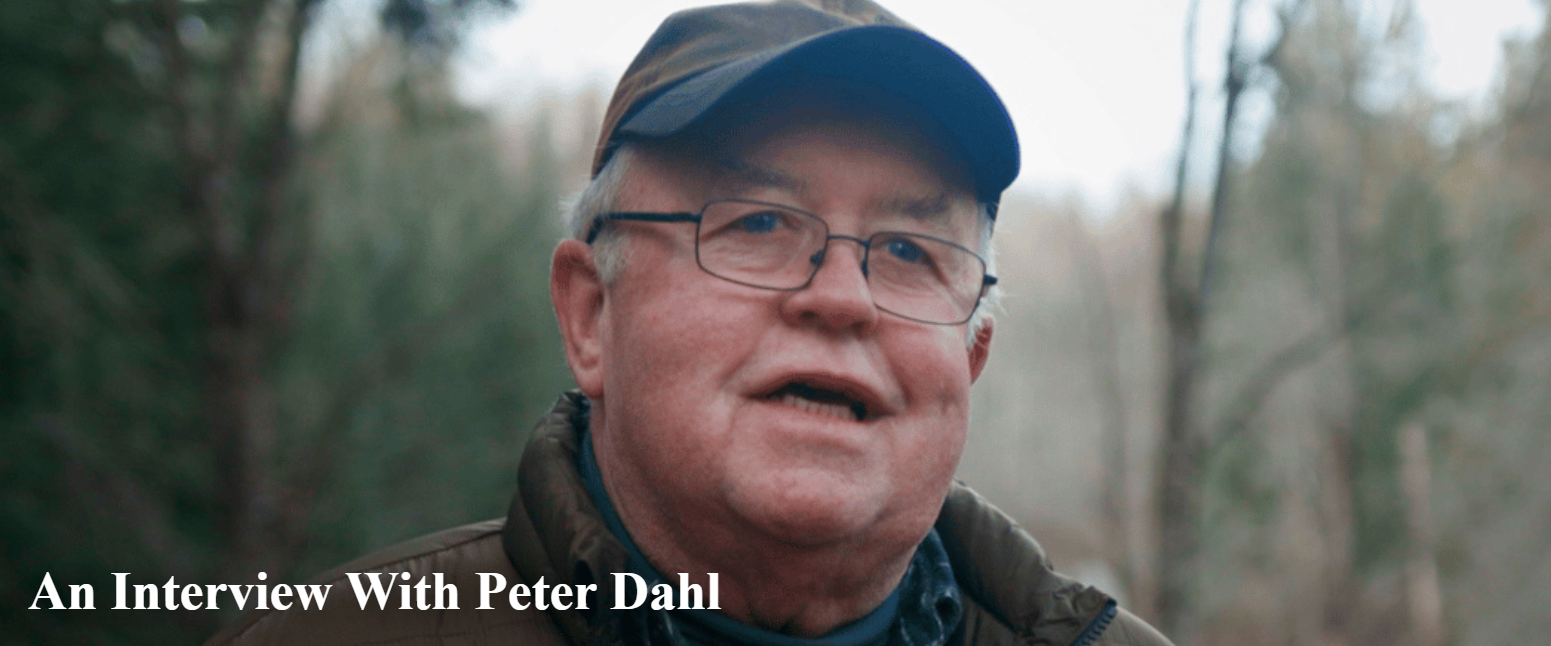
On a sunny day in December, 2025, we met Harold at his country home and drove him to nearby Bancroft to pick up some food supplies. On the way, we stopped for a coffee and found out more about his life and his commitment to conservation.

Can you describe life on the family farm when you arrived there in the late 1940s?

It was subsistence farming. We had a dozen chickens, a cow for milk, a couple of pigs, the odd calf and goat, and a horse for work. There were always apples from the orchard, which we sold by the roadside, stored, and made into sauce and cider. Our garden gave us vegetables to eat fresh in season, and store for winter.

My father Louis could always put a meal on the table with the fishing rod. He would walk to lakes nearby and come home with speckled trout. He had a rod with no reel – I remember him whipping around the line to cast, then reeling it in, hand over hand, when he caught a fish. He had a .22 rifle as well and would bring home some partridge, rabbit and squirrel for dinner.

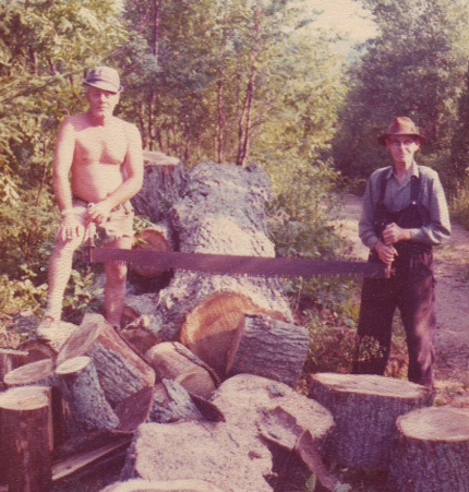
Dad did some lumbering in winter and some roadwork for the township for cash – 60 cents and hour back then.

My mother Alice raised three kids, made our clothes in the early years, cooked, baked, helped my father on the farm, and spent many hours putting away food for the winter – preserving, drying and storing nutritious food to last until spring. Mom also tended a flower garden. Many of her flowers are still blooming to this day in summer – iris, crocus, rose, narcissus and daffodils to name a few. The biggest time consumer for my parents was cutting wood for fuel – especially before we had a chainsaw, horse or vehicle.

Our family didn’t have a big income — but we always had food on the table. My sister, brother and I always had presents for birthdays and Christmas. We didn’t have costly toys but we were creative – like making a fort out of a cardboard box.

We went to a two-room schoolhouse in Wilberforce – one room was Grade 1 to 4; the other was Grade 5 and up. I remember there were only two of us in Grade 5 and I always came second!

When did you learn to hunt and trap?

I started with a bow and arrow for rabbits. When I was 12 years old, I started my first trap line – a few snares around my family’s property. I got mostly squirrels, weasels and mink. Then I would trap the odd beaver, muskrat and fox. I sold my furs to Hudson’s Bay in Winnipeg. I would pack them up and put them in the mail, and they would send a cheque back.

You mentioned that after you finished school, you had worked for the province for several years. Why did you return home to Harcourt?

I was working as an instructor with a Ministry of Corrections program called Project DARE – with the goal of building self-esteem in young offenders. It was based on the philosophy of the Outward Bound program.

On one hand, I enjoyed the work and was making good money. On the other hand, I was getting sick of the workplace politics. Also, I realized that a lot of my income was just flowing out of my hands to taxes and expenses like gas and rent. I felt I was caught in a trap of society and its capitalist system.

At that time, my father gave me some great advice – he told me: “If an average person would work just as hard for himself as he has to for others, he’ll never go wrong in life.”

I realized I could always trap. I had the skills to trap and handle furs. To go along with my family’s 100 acres, I knew I needed more land to be able to trap sustainably. I scouted some bush acreage at reasonable prices and started to purchase some in the mid-1970s.

I transitioned from my government job into a more self-sufficient lifestyle. I could reduce my expenses and make some income with the fur harvesting.

How were things for you in your first few years back in Harcourt?

The Ontario Trappers Association came along and gave some competition to the Bay and better prices for trappers. Fur prices increased. A fox pelt that I used to get 50 cents for was paying a hundred and thirty dollars. A beaver pelt worth two dollars had gone up to a hundred and forty dollars. 

So I could get by – I made about $3,000 in my first year or two. By living off the land, and living economically, I was doing well. I gradually bought more land and in some cases was able to resell it later.

What were some of your principles for sustainable fur harvesting and farming?

I was an efficient trapper – while I owned a snowmachine, I chose to snowshoe or walk into most of my lines. As well, I could process the furs in the bush and walk out with them. My biggest line was about 40 traps, maybe two miles long. I would be in there for a day and walk out.

Trapping sustainably also means rotating your lines, and paying attention to the wildlife populations. For example: What’s the main food for a beaver? It’s poplar. You keep an eye on the territory and see where beaver populations are doing well, what poplar sources they have. In the offseason, I have done a lot of culling of conifers around ponds to allow the poplar trees to regrow for the beaver population. You want the wildlife populations to be stable or growing.

It’s the same in the garden – you can’t just take, you have to put back. How did I grow a 50-pound squash? By paying attention to the soil. By using compost and finding natural ways to put nitrogen, phosphorus and potassium back into the soil for the next crops. And in the apple orchard, you take care of the soil and protect the trees.

You treat the land as something you care about and are passing on to somebody. I also want to protect my land from unhealthy forms of development that are spreading around the province. I’m not against development, but some forms are not sustainable.

Biologist Paul Heaven did a comprehensive assessment and forest management plan for your 375 acres on behalf of the land trust. It’s a detailed report showing the forests, wetlands, rocky barrens and wildlife on your lands – also your trapper’s cabins and the trails you’ve made over the years. Paul found species such as deer, moose, red fox, eastern wolf, black bear, amphibians, many bird species, as well as diverse tree and plant species.

What’s it like to look at the maps and observations in the plan for your property?

I know it up here (pointing to his head) but it was fun to look at the maps and to speak with Paul. For example, we texted back and forth about a cranberry bog. I remembered it, and I hiked back there recently and discovered another spot where I picked a quart of cranberries. I texted Paul and told him about the harvest and let him know I would be staying there in the bush for a week or so. He texted me back and said he was jealous!

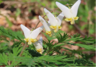
Dutchmen’s Breeches are one of many diverse plant species on Harold’s acreage.

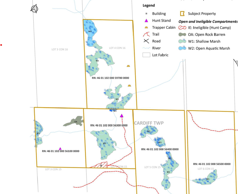
Portion of a map of Harold’s five adjoining properties of forests, wetlands and rocky barrens totaling 375 acres.

You became a Partner in Conservation with the Land Trust last year. There are currently more than 60 partners representing over 10,000 acres — and the program’s now open to any landowner in Haliburton County.

What would you say to someone who might be thinking about becoming a Partner in Conservation?

Each person would see the benefits differently. You are helping with research about the forest and wildlife corridor. There’s a tax benefit from the managed forest program. You get a long-term plan and support to manage your land sustainably.

If you care about preserving your land, it’s worth considering.

Back from our trip to Bancroft, we help Harold bring in a large box of oatmeal and tub of beans from the whole food store. In his 80s, he’s slowing down a bit and so purchases a few more staples. Today, he’s stocking up for maple syrup season next March and April, when he will feed some friends who help with the operation of tapping trees, gathering and boiling sap.

Before saying farewell, we stop to chat in the sunshine outside the stone house he built with mostly local materials in the late 1960s, just down the road from his parents’ farm.

Right next to Harold’s home are some mature apple trees, one with a ladder resting in it. Harold admits he rarely goes up the ladder anymore, but he’s proud of his trees. One is a Wolf River variety – producing a fine cooking apple. Many years ago, he had taken a branch from a Wolf River tree down the road and grafted it to rootstock here.  It took him a few years of failed attempts before he matched up the graft to the right rootstock, but the result is a solid producer of apples for his cellar. To his taste, it’s the sweetest Wolf River around.

You’d think it’d be tough to grow apple trees in this area with its cold winters. But with the right touch and stewardship, Harold has nurtured not only apple trees but also pear, cherry, and many varieties of plum, not to mention grapes and berries.

His is an unconventional life that goes well beyond self-sufficiency — to a richness of experience and stewardship of the natural world.

A sustainable life.

Article and interview by volunteer Ian Kinross.

Photos by Ian Kinross, Rick Whitteker and Paul Heaven.

For more information on the Haliburton Highlands Land Trust and its Partners in Conservation Program: please visit: https://www.haliburtonlandtrust.ca/

Additional recommendations from Harold Hart:

  1. Living the Good Life – a book by Helen and Scott Nearing about their self-sufficient homesteading project in Vermont.
  2. Fit for Life – a book by Harvey and Marilyn Diamond advocating a diet prioritizing fruits and vegetables.
  3. Last but not least, Harold recommends that property owners in the Haliburton region consider the Partners in Conservation Program: “Each person can do their part to save our natural world and planet.”

A River Runs Through it

The Burnt River connects the Dahl Forest — located south of Haliburton, Ontario — to its greater region, watersheds and wildlife.

The river has been an important travel route for native peoples, a conduit for the lumber industry, a water source for farms, and a gorgeous recreation route for travellers of yesterday and today.

Earlier this year, I had the pleasure of interviewing Peter Dahl, whose family donated the Dahl Forest property to the Haliburton Highlands Land Trust in 2009. Peter spoke of the human history of the Dahl forest and the regeneration of its flora and fauna over the years since his parents purchased it as depleted farmland.

In this third of three interviews, Peter looks at the role of the Burnt River as a focal point in the Dahl’s history and connection to the natural world. (For the complete interviews, please visit the land trust website here: An Interview With Peter Dahl)

Fall colours along the Burnt River, looking downstream from Dahl Forest. Photo by Peter Dahl

How did the Burnt River get its name?

I’ve been told two versions. One is that it was named by early explorers after a big forest fire that came up the valley. The other, which I prefer, is that the gravel bottom and rocks are a very dark colour; I believe this is due to iron minerals staining the rocks.

What does the Burnt River mean to you in terms of the natural world?

The river is the focal point of the Dahl Forest. Everything can be related to the it: your distance from it, your altitude above it. All streams at Dahl Forest flow to the river. If you are walking at Dahlf Forest, eventually you will be standing by the river.

Many plants, animals and birds are found there that won’t be found elsewhere. The river is also a place where wildlife drama unfolds, like the time we saw a deer take to the river to escape a group of coyotes. Beavers are regular visitors making caches of sticks along the banks.

A family of merganser ducks swimming with their newly hatched brood is an annual springtime event. As the ducklings mature, they work as a team to chase small fish into the shallows where they’re easier to catch.

You described the Burnt River as a commerce route for the lumbering of Ontario’s old-growth pine. Did the original homesteaders in the Dahl Forest participate? 

All of the settlers here, to the best of my knowledge, sold off their pines to logging firms, primarily to Mossom Boyd from Bobcaygeon. Logging was winter work for settlers, one of the few opportunities to find a wage income. Some of the men went to work in logging camps, leaving wives and children to tend to the farm and livestock.

The only possible time to get large logs down the river was the spring flood. There is an old mill downriver in Kinmount. I understand that the Boyd operation sent milled logs all the way down to Lake Ontario and the St. Lawrence River, where they would be shipped to Europe and England from Montreal or Quebec.

In the previous interview, you indicated the Burnt River was a major travel route for indigenous peoples. You found a carved stone pipe there dated to the Algonquin culture. If we fast-forward to today – is the Burnt River used for recreation? What about watershed management?

It’s a lovely canoe trip from Haliburton village by canoe down to Kinmount. We see people canoeing and kayaking in the summer, but not as many as I would expect for such a wild and natural river so close to developed cottage country.

Like most watersheds in Haliburton County, authorities control dams that restrict water flow to the south. Their dilemma is to balance lake water levels for cottagers and residents in the county with the needs for flow in the Trent-Severn canal system and Kawartha lakes.

You and your spouse Jan have taken many journeys in North America, including a time when you lived in the high arctic. Can you tell us more about the canoe journeys you took along the Burnt River to Kinmount? 

It takes about four hours to paddle from Dahl Forest to Kinmount, which makes a lovely summer day with a picnic along the way. We have also camped overnight at one of the 2 or 3 camping spots downstream of Dahl Forest.

The river passes through mostly wilderness downstream to Three Brothers Falls. It’s somewhat challenging at spots along the way due to shallow flats and rocky fast water areas. I would not recommend taking a high-end canoe; you’re certain to bash a few rocks along the way. However, because the current moves you along, it’s fairly effortless.

When you reach the falls, you must portage around them, of course. They’re an impressive torrent with three substantial waterfalls.

As you continue downstream of the falls it is a pleasant and scenic trip to Kinmount, where you can buy an ice cream cone to top off your journey.

Photo: Haliburton Highlands Land Trust

Update: The ice storm in early 2025 caused significant damage to the Dahl Forest’s canopy. The land trust has been working diligently to clear trails and re-open them to the public in fall 2025.

Kindred Spirits — the human history of the Dahl Forest

Indigenous peoples and pioneering homesteaders are part of the human history of the Dahl Forest, near Gelert, Ontario. Artifacts signal the presence of indigenous peoples who long ago used the Burnt River as a major travel route. While the homesteaders are long gone, evidence of their toil to farm this rugged land remains.

Peter Dahl was a young boy when his parents purchased the Dahl Forest lands in the 1950s. In 2009, Peter and his family donated the former 500-acre farm to the Haliburton Highlands Land Trust. We asked Peter to share his memories of the Dahl Forest’s human history.

The survey done of Dahl Forest for the land trust showed the remnants of the Strafford homestead in the northwest corner of the property. The Straffords had immigrated from Berkshire, England in the 1870s to accept a “free-grant” farmstead here. What do you remember about this homestead?

The Strafford’s log house still stood when our family purchased the land — I used to play in there as a kid. There was an attic accessed by a ladder from outside. I recall going up there and seeing old newspapers used for insulation. One of them had a headline about the Czar of Russia, so it must have been placed there around the turn of the century.

Inside, I recall a pump organ – the kind of organ you had to pump your feet to play.

Mr. Strafford had been integral in building the S.S. #6 school that still stands nearby, next to Geeza Road. We know that he was a school trustee and a lay preacher, in addition to farming.

The land trust plaque near the foundation of the old homestead says that the Straffords left for Nebraska in the 1890s, after about 20 years trying to make a go of it. What was life was like for homesteaders like them?

They were given free land — but the labour to settle it, clear it and farm it was extreme. On all the homesteads here at Dahl Forest, you can see evidence of the human toil to clear stone, for example.

As a kid, I saw these massive stone piles and long stone fences that the homesteaders had built up while clearing their fields for cattle and crops. Some of the bigger stones must weigh a ton or more.

After all of the back-breaking work they put into it, it must have been a terribly hard decision for a family like the Straffords to walk away from their home and farm here. Nebraska would offer them more fertile soil and a better chance.

Let’s continue our tour of your homestead memories. Were there other pioneers in this north-west section of what is now the Dahl Forest?

The Miles homestead was near what’s now the north gate of the Dahl Forest, east of the Staffords. Almost nothing of it remains today.

When I was young, our family came upon a children’s gravesite towards the Miles homestead. I remember a circular picket fence that sat in a field of rolling grass. Some lilacs had been planted in the middle. There were no markers left, but it was clear that it had been used as a burial site. The site used to appear on aerial photographs as a black dot.

Nobody knows which children lie there. We thought it could be children of either the Miles or Stafford families, or both.

Looking back, we know that the many pioneer families lost children to diseases caused by poor nutrition, polluted well water and weather extremes. And doctors were hard to come by. Pioneer life was even tougher when it came to the survival of children.

You mentioned that when your family purchased this land in the 1950s, you would come up from Lindsay and stay in the former homestead of the Bowhey, then Schrader families. This was near the main entrance to today’s Dahl Forest on Geeza Road.

My dad renovated the Schrader house into a recreational cottage when he first purchased the property in 1955. That was our place until the current cottage, which is now our house, was built in 1976 next to the river. The original homestead was demolished by the land trust for safety reasons a few years ago as it was deteriorating badly.

Were the Schraders still farming when your family purchased the property?

Yes, the Schrader family had still been raising some cattle there. The cattle ranged freely around the hills around the river; I remember hearing their bells in the distance. The cattle wintered in the barn near the homestead.

The barn was in good shape, and I played in there as a kid. There were piles of hay and straw and ropes to haul it in. There was an old cutter in there — a horse-drawn sled for trips to town in winter. And the body of a Ford Model A car. My dad didn’t need the barn, so he had it torn down and kept the utility garage nearby. You can still see the stone foundation of that barn next to one of the Dahl Forest trails.

Bowhey/Schrader barn in the 1950s.

I see you’ve kept and displayed some of the farming implements from the barn. I’m sure each one has a story to tell.

The cross-cut saw was used to saw logs by hand before they were split. The cow bells were to keep track of the cattle that ranged freely on both sides of the river. The scythe was used to take hay by hand. Looking at the whiffle-tree harness, you can visualize a pair of horses hauling lumber in winter.

You can imagine a totally different world – almost third-world conditions with no electrical power, plumbing or telephone, no cars, and a tremendous effort to survive. The well was about 50 metres from the house, with water carried by bucket.

How did things change for the homesteaders in this area over the years?

Besides the cattle and some crops, they also looked to make some cash selling gravel and wood-cutting.

But it was a hardscrabble life. People needed steady income. Gren Schrader went to work at the CNR as a telegraphist and railway manager. Likewise, most of younger generation around here heard about good jobs elsewhere – I know some of them went to work for GM in Oshawa for example, rather than stay on the farm.

Gren and his son Rob preserved a lot of history about the Dahl Forest and this area and its people. Rob Schrader is a friend of mine and still visits a cabin he owns further along Geeza Road.

Gren Schrader, left, helps Raymond Geeza saw logs for firewood in 1974. Gren was 44 at the time of the photo; his cousin Raymond was 89 and, as Gren recalled, had more stamina with the cross-cut saw! (Photo courtesy of Schrader family.)

Are you aware of any history of indigenous peoples in the area of Dahl Forest?

My understanding is that the Burnt River was a major travel and trade route for indigenous peoples between lakes in the Haliburton area and the Kawarthas. Almost three kilometers of this river runs through the Dahl Forest.

When I was a child, Tommy Hoyle, whose family lived just north of the Dahl farm, gave my dad a stone axe head that he had found near the river.

When Jan and I were canoeing down the Burnt River towards Kinmount, I found a marvelous stone pipe lying on the bottom of the river about a kilometer or two downstream of the Dahl Forest. It was about six inches long, with the bowl canted forward a bit. It likely had washed out of the riverbank; it was a stroke of luck that I found it.

I had it examined at Wilfred Laurier University’s archeology department and a scientist there appraised it as being pre-contact, from the Algonquin culture. The pipe is now in the Haliburton museum.

Stone pipe from Algonquin culture found by Peter Dahl near Dahl Forest. It is part of an exhibit of indigenous artifacts at the Haliburton’s Museum. The ridges in foreground were likely once decorated with brightly coloured inlays, and the bowl of the pipe may have had a wooden figure attached, such as a bird’s head. The museum offers a report by David Beaucage Johnson on the history of indigenous settlement in Haliburton County. You can find it at this link: //database.ulinks.ca/items/show/4842

For the complete interviews with Peter including the Dahl Forest renaissance and connection to the Burnt River, please visit the Haliburton Highlands Land Trust website here:

https://www.haliburtonlandtrust.ca/2025/04/peter-dahl-interview/

From forest to farm and back again — interviews with Peter Dahl

Peter Dahl has been connected to the Dahl Forest ever since his parents purchased the former farm in the 1950s. In his lifetime, he’s seen the Dahl Forest undergo a renaissance. Tracts of conifers planted by the Dahl family on depleted farmland are maturing, with a mixed-forest understory emerging beneath. Meanwhile, its natural mixed forests, long ago logged for their massive pine, have regenerated.

In 2009, Peter, with his mother Peggy Dahl and sister Nana McKernan, donated their 500-acre property near Gelert to the Haliburton Highlands Land Trust. Peter and his wife Jan now split their time between a private residence in the Dahl Forest, overlooking the Burnt River, and another home in B.C., close to their son.

With its network of trails, the Dahl Forest is a magical nature reserve, a place to hike, snowshoe, birdwatch… or just get a little fresh air and forest therapy.

As the forest regenerates, its wildlife is returning. Fur-bearing creatures like the beaver and martin are back. Wetlands and their unique wildlife are on the rebound, fueled by many creeks and springs, and cradled by new beaver dams. In winter, the tracks of larger mammals like moose, deer and coyote crisscross the forest.

Peter is also keenly aware of the forest’s human history and the kindred spirits it hosts. The artifacts of homesteader families remain, as does evidence of their toil to clear and farm challenging terrain.

And a river runs through it – the majestic Burnt River, connecting this splendid forest to the greater region, watersheds and wildlife.

On a couple of crisp mornings in February, 2025, Peter stoked the woodstove in the Dahl residence next to the Burnt River, and shared memories and his thoughts about the Dahl Forest’s human and natural history. Following is part 1 of the interview series. For the full story, please visit: https://www.haliburtonlandtrust.ca/2025/04/peter-dahl-interview/

Forest Renaissance

Your family planted more than 100,000 trees on depleted tracts of farmland here. Can you tell us more about this pic of two young tree-planters?

That’s me on the left, with my school friend Bill Szego. Our family lived in Lindsay, and we’d come up to the farm on weekends. In the photo you can see Bill and I seated on a planting machine pulled by a tractor. My dad Eric or a hired hand would have been driving. My dad likely took this photo.

The machine cuts and splits the soil. Bill and I would take turns planting the pine seedlings at intervals measured by a string. The two canted wheels of the machine would then squeeze the soil back together around each new seedling.

Why were the trees planted? Were you ahead of the curve on rewilding?

My Dad’s original intention for planting the trees was to get a cash crop. He was from Sweden, which has a long tradition of managed forests for lumber. In Europe, there was also that mythology about the wild west in North America. He was excited to own a piece of the Canadian wilderness, to have this land as a place to hunt, trap and fish. At the same time, my parents were always open to share the land with others. That idea was also part of his Swedish heritage.

It takes a long time to grow trees for saleable lumber. How did the plans for the Dahl farm change over the years?

Dad lost interest in the lumber cash crop. When we investigated the option further, it wasn’t economically viable.  We did do some thinning of the pine plantations but as time went on, we decided to let nature take its course.

Also, for mom, my sister and I, the farm had always been a place to get away to and enjoy. Mom really loved it here. She was born in Guelph and professionally trained as a violinist. She once worked as a music instructor at a girls’ camp in Algonquin Park. I believe that for a city girl, that experience, including the wilderness canoe trips she went on, was important to her love of nature and the outdoors. When my parents were courting, they canoe-tripped extensively.  Mom loved the natural world that was part of the Dahl Forest. When my parents divorced in the 1980s, Mom retained ownership of the farm.

Mother nature can be a powerful force over time, if you allow it. What we’ve seen over the years is that the natural forests here are thriving again. That includes some of the hardwood areas as well as the original dominant species of pine returning. In the plantation areas, we’re now seeing some self-thinning of the bigger trees, and a new diverse understory of species like maple, poplar and balsam fir coming up.

How does this affect the wetlands and water courses here?

One of the amazing things is the water table has risen! I’ve recently seen springs pop up in places we’ve never seen before. With an expanded forest canopy and roots, the creeks run longer. The wetland and pond areas are expanding – some large ponds are now small lakes.

What about animal species in the Dahl Forest?

The changes we see here with the forest and wildlife are all connected.

The beavers were trapped around here until about 25 years ago but they’re back now and living in the banks of the Burnt River. We know they’re thriving because we can see beaver families from our window next to the river. They’ve also built at least eight new dams in several of the creek and wetland areas.

Many other creatures of the forest are returning, like mink, fisher and martin. We saw our first martin not too long ago – it caught a squirrel near the house. Moose and deer are prominent here now, along with their predator species including wolves and coyotes.

The change is slow, like the tide. When you see new things, you step back and say: “Wow.” It’s gone from forest to farm and back again.

(Peter in winter 2024/25 next to a tree he planted as a child. Photo by Jan MacLennan)

Why is it important for you to talk about the history of Dahl Forest?

I’m in my mid-70s now. I realize that some of my knowledge – like the location and memories of the homesteads here, and how the place evolved in my lifetime – will be important to share with future generations.

The concept of stewardship is important to me. The oversight and protection of the natural world is ultimately tied to the concept of caring. That means caring for the land, its health, beauty and future. The Dahl Forest now belongs to the community, and its spirit will continue and be cared for.

Mapping the Dahl…

Peter shares a diagram from a detailed ecological report on the Dahl Forest. On the map above, created by Glenside Ecological Services for the Haliburton Highlands Land Trust, you can see some of the reserve’s original natural forests that Peter mentioned. The dark areas shown in the south-east corners of the property, for example, represent mostly natural white and red pine forest, mixed with some red maple and balsam fir. There are also large areas of natural mixed forest comprised of balsam fir, red maple, trembling aspen, basswood, sugar maple, white birch, white spruce and nine other tree species.

The main plantation areas – where the Dahl family planted more than 100,000 conifers – are marked in a lighter colour, such as sections in the central/west area near the main entrance, road and river.

Wetlands shown in the north and south areas of Dahl Forest continue to regenerate with the expanding forest canopy and return of species like the beaver.

*****************************************************

Peter throws another log on the fire to keep the place cozy on a crisp winter day. The thermometer showed minus 27C first this morning. But as the sun comes up to break the chill, a few intrepid hikers have already parked near the entrance to the Dahl Forest on Geeza Road. They’re heading out for a winter walk on the forest’s public trails.

(Update: Some areas of the Dahl Forest were hit hard by the ice storm in April 2025. The land trust is assessing the damage and working to clear the public trails and repair other damage.)